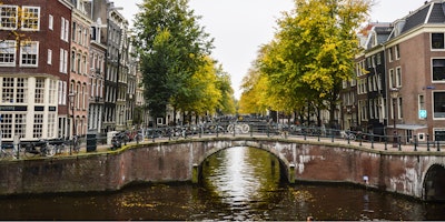
Amsterdam's canals
The inner city of Amsterdam is intricately woven by a network of canals, dividing it into around 90 "islands," with the municipality overseeing approximately 1,300 bridges and viaducts. This remarkable canal system is the outcome of intentional urban planning carried out during the early seventeenth century, a period marked by significant immigration.
A comprehensive city plan emerged, built around four concentric half-circles of canals, each extending to the IJ bay. Referred to as the "Grachtengordel," three of these canals primarily served residential purposes: The Herengracht (Gentleman's Canal), Keizersgracht (Emperor's Canal), and Prinsengracht (Prince's Canal). The fourth and outermost canal, the Singelgracht, functioned as a defensive structure and water management system, combining moats and earthen dikes, fortified by gates at strategic transit points.
Today, Amsterdam's canals primarily serve as thoroughfares for transportation and offer delightful opportunities for leisurely cruise experiences.
If you are looking for a home in Amsterdam, try searching in these different city area's: Amsterdam West - Amsterdam Zuid (South) - Amsterdam Centre - Amsterdam Noord (North) - Amsterdam Oost (East).


